十勝沖地震に伴う津波の河川遡上
最終更新 : 2003年9月30日
十勝川,新釧路川,沙流川,鵡川,2003年9月
十勝沖地震伴い発生した津波の河川遡上調査概要報告
Report on River-runup of Tsunami Generated by the Tokachi-oki Earthquake on 26 September, 2003
北海道開発土木研究所環境水工部河川研究室
Summary of the event
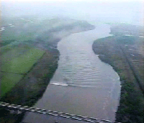
Two strong earthquakes occurred off the southeastern coast of Hokkaido in northern Japan on 26 September 2003. The earthquakes gave various damage in the southeastern part of Hokkaido. A number of tsunamis associated with the earthquakes have been observed on the southern coast of Hokkaido as well as the northern part of Mainland. The characteristics of the tsunami are that the wave propagation exceptionally continued longer than a day because of the generation of edge wave, and the tsunami ascended many rivers as much as approximately 10 km away from its river mouth. In this site, the properties of the river-runup of the tsunami were discussed on the basis of the hydrographs of the water level and results of the field surveys on Tokachi river, Kusiro river, Saru river and Mu river.
1.調査概要
調査日時;2003年9月30日,10月4,5日
調査員;安田 浩保 研究員
1.調査結果概要
- 2.1.十勝川(現地調査写真,水位記録,痕跡調査結果)
- 2.2.浦幌十勝川,下頃辺川(水位記録)
- 2.3.釧路川(水位記録)
- 2.4.沙流川,鵡川(水位記録)
- 参考資料(a) 十勝川を遡上する津波ビデオ(陸上自衛隊撮影)