Report on Asian tsunami ascending the river,and its associated bank erosion and bridge failure in Sri Lanka
Last update : 03/28/2006
SURVEY ON TSUNAMI RUNUP IN THE RIVER
Sri Lanka is on the continental shelf . Shortly after the occurrence of the tsunami, a number of researchers conducted surveys on the tsunami height on Sri Lanka's coast. In the eastern coastal area, evidence of tsunami 10 m high was identified in many places, and in some places there was evidence of tsunami as high as 15 m.
The two rivers examined in this investigation are the Yan Oya River and the Mahaweli Ganga River . Oya is Srilankan for "a river that appears only during the rainy season", and ganga means "a river that flows throughout the year". Along the eastern coast of Sri Lanka, which is characterized by strong tidal currents and a substantial flow of drift sand, there are several lagoons, and there are sand-spits at the river mouths. For this reason, the water at estuaries is extremely shallow, which is quite different from the lower reaches of rivers in Japan.
1) Yan Oya
As most of the rivers on Sri Lanka's eastern coast flow into the ocean through lagoons along the shoreline, few of them have a simple river mouth profile. The Yan Oya River is one of the few that possesses a relatively simple mouth profile (Fig-1). The water in the estuary is very shallow. At this estuary and others in the area, there are sand-spits.
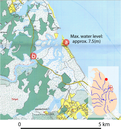
Fig-1Yan Oya River mouth (Point (b) is about 3.5 km from Point (a). Mangrove trees on riverbanks in this section may have contributed to the dissipation of energy from the intruding tsunami.)
Many palm trees that were broken at the crown* were detected in Kallarawa Village, at the river mouth (Point (a) in {Figure\ \ref{fig:map_yan}}). Based on the marks left by the tsunami on these trees and on interviews with local residents, it was found that the maximum tsunami height in this coastal area was 7 m. Although traces of damaged (uprooted/ knocked down) vegetation, soil sedimentation and scouring were observed along riverbanks near the estuary, their severity was not great considering the scale of tsunami runup along the seashore. This is attributed to the lack of obstacles along the seashore and the shallowness of the water in the estuaries, in which there are sand spits. These cause a tsunami intruding into the river channel to lose energy.
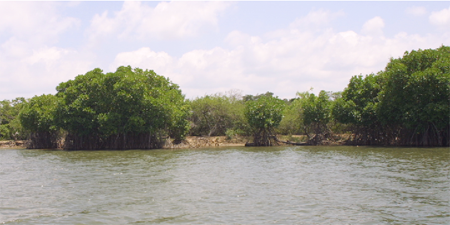
Photo-1 Mangrove on the Bank of Yan Oya River
According to residents living in a village 3.5 km upstream from the estuary (Point (b) in Fig-1), the river water level rose 0.5 m there, and some places experienced a 4-m rise of riverbed at the time of the tsunami intrusion. The water level increase was small at this location, considering the maximum height of the tsunami at the estuary and the elevation of this location. This is partly because of energy-dissipation by the mangrove trees that grow densely along the riverbank from the estuary up to this place. It is assumed that the propagation of the tsunami in the river channel was blocked by two factors: mangrove trees and the river mouth profile.
*In estimating the tsunami height from palm trees, only those broken at the crown were used. A change of frond color to brown was observed in some palm trees from the lower end of the crown to the middle. Because it was hard to believe that palm leaves withered only by exposure to seawater, they were excluded as physical evidence. It is possible for the soil salinity to have increased from tsunami runup, promoting browning and withering of old leaves at the lower section of the crown
2) Mahaweli Ganga
The Mahaweli Ganga River has the largest drainage basin in Sri Lanka, discharging into Trincomalee Bay and the Indian Ocean. In this research, the river mouth near Mudduchchenal Village on the Indian Ocean ({Figure\ref{fig:map_maha}}) was investigated, as it has a relatively simple profile, as does the Yan Oya River.
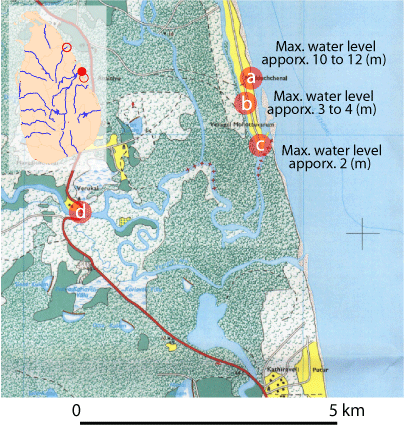
Fig-2 Mahaweli Ganga River mouth (The maximum water level mark was 4 m at Point (b) and 2 m at Point (c). The difference may be attributed to the density of obstacles. The distance from Point (c) to Point (d) is about 3.2 km.)
Mudduchchenal Village, which stood near the river mouth (Points (a) and (b) in Fig-2), was totally destroyed by the tsunami and is currently uninhabited. The maximum water level of the tsunami in the palm tree forest along the coastline (Point (a) in {Figure\ref{fig:map_maha}}) was estimated to be 10 to 12 m, according to the bending of palm trees. The average water level along a tree-lined street in Mudduchchenal Village (Point (b) in Fig-2) was estimated to be 3 to 4 m, judging from collapsed houses and the bending of young palm trees. In the area along the river channel (Point (c)), the maximum water level judged from traces on houses was 2 m or so. Great locational variation was observed. This is because within the village, street-side trees and structures caused the water level to increase by interrupting the inundating flow, whereas along the river channel, few obstacles interrupted the flow of the tsunami.
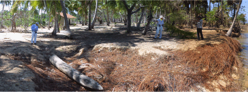
Photo-2 Riverbank scouring thought to have occurred at the time of water retreat (The soil was scoured to the depth where palm tree roots are densely distributed. The photo was taken from the left bank of the Mahaweli Ganga River mouth, near Mudduchchenal Village, looking toward the river mouth.)
Sediment transport induced by the tsunami runup was investigated at the riverbank near Point (c). Scouring, which may have been caused by return flow near the river channel (Photo-2) and 0.3-m-thick sedimentation 50 m inland from the riverbank, were confirmed. Both were already at the final stage, and the process of their formation was unknown.
3) Comparison with the tsunami runup in the river in Japan
In Japan, the intrusion of tsunami in the river several kilometers upstream from the river mouth can be clearly observed in rivers gentler than 1/5,000 in bed slope, even when the maximum tsunami height at the estuary rises to about 1 m. As previously stated, in Sri Lanka's eastern coastal area, where the survey was carried out, tsunami intrusion into the river channel was observed only in a limited proximity to the river mouth even in a river where the tsunami height was higher than 5 m at the estuary. This suggests a completely different mechanism of tsunami intrusion between Japan, where rivers tend to have relatively uniform gradient all the way to the estuary, and Sri Lanka's east coast, where many rivers have a sand-spit and shallows near the estuary.
- SURVEY ON TSUNAMI RUNUP IN THE RIVER
1) Yan Oya
2) Mahaweli Ganga
3) Comparison with the tsunami runup in the river in Japan - DRAINAGE OF WATER INTO SMALL CHANNELS
- DAMAGE TO BRIDGES, AND NEARBY TSUNAMI TRACES